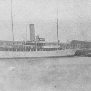
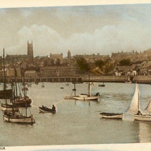
Very good - can even make out the FV registration, therefore can be dated. I am interested in the features alongside the viaduct, by what I think of as Oxnam s Pool and the present Dry Dock area....
Sorry, I do not normally like shortened versions, put it down to excitement. Unlike MJS, CH, et al, including PZM, FV is a recognised abbreviation; vessel PZ 630 or perhaps 639, may be an aberration on the print; what is clear is the hoist shed on the front of the blessed Coulson s Granary.
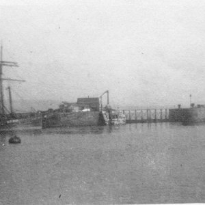
I will have to scrutinise this (with long deep scroots) one appears to be a grain silo, there is another squarer one behind it. The whole arrangement has changed of course (for the moment I have mislaid my 1908 OS map); in 1875 the Dry Dock was in the opposite direction, but here the slip is showing (must be the wind) at the left . There is another large building, where the Matthews sawmills were, not entirely sure what is happening. I will have to check through a lot more yet. What else is very apparent is the line of trees across the picture, which I have no doubt was historically a belt of trees along the cliff tops.
So far this appears to be 1925-30, showing Holman s Foundries on Wharf Road. I haven t managed to check the Fishing Vessel records, as the cat is occupying the rest of the bench. May as well have a which hunt for the 1908 map, as the features do not appear on the 1936 map.
The area now occupied by the great worksheds of the Dry Dock, was a virtually open space, with two silos and the Ship Foundry, which is the large building next to Coulson s Granary. Originally the Dry Dock was over by the top of the present slip, and was at right angles to the present Dry Dock. At the far left are two small buildings which later were demolished. Behind them is the Bonded Store which is occupied by the Dry Dock Office and Bosun s Locker. In 1901 a new Bonded Store was built (can be seen to the right of the top of The Seamen s Institute and still exists with the Isles of Scilly Steamship Company). It is often quoted the the Wet Dock dates 1880, but it was completed, with the rest of the Dock Work in 1884. The new Dry Dock was built in 1880 along with the work to Wharf Road, and the Ross Bridge opened in 1881.
The amount of work involved in moving stone and shore ground, and then building with massive infill was a project which I suspect would fill the modern contractor and local authority with some dismay. When Building Regulations were changed a while ago, I had to provide structural assessments for the use of granite ... Duhh. Hello, is anybody in there?
So, why the silos? What is the date ... I am working on it ....
This site uses cookies to help personalise content, tailor your experience and to keep you logged in if you register.
By continuing to use this site, you are consenting to our use of cookies.