You are using an out of date browser. It may not display this or other websites correctly.
You should upgrade or use an alternative browser.
You should upgrade or use an alternative browser.
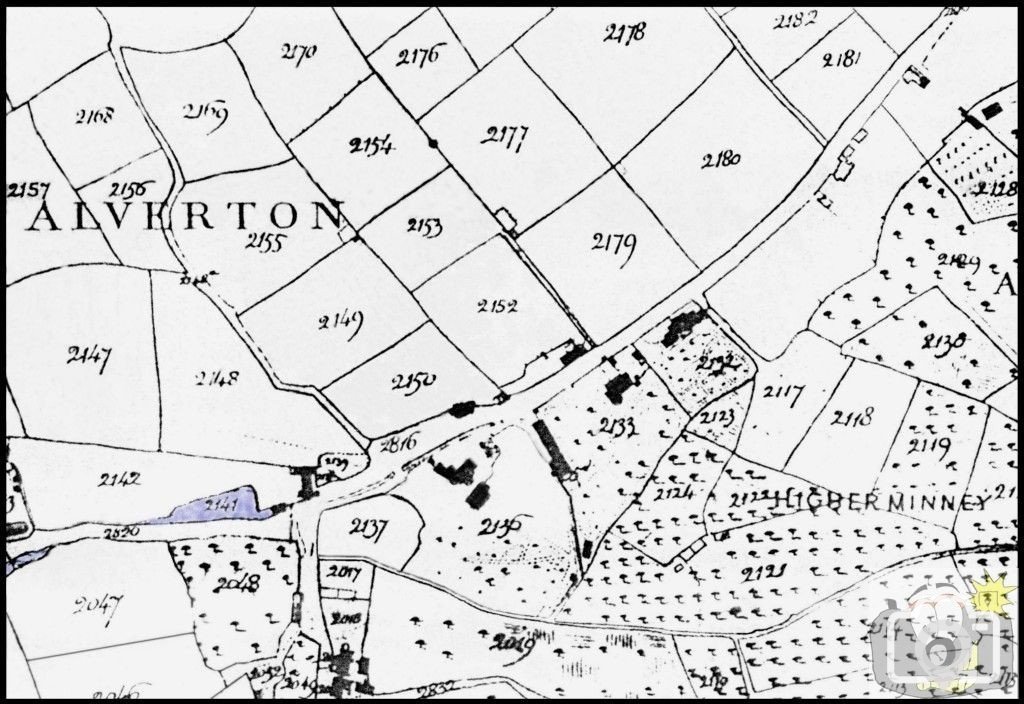


Alverton Bridge - map
The 1839 Tithe Map.
The original 1865 iron railing has been removed -
In connection with 'Tredarvah Farm'
and a photograph of the corner, yet to be uploaded.
Alverton Bridge and Luke Rowe’s Cottage.
The dating of the bridge at Alverton, over Lariggan Brook can be taken approximately,
thanks to William Bottrell, in his tale of the Reverend Spry
and by reference to the Tithe Map of 1839 and 1843 as well as the OS of 1875.
[Rev Wm Spry; BA, MA. St Levan 1815-1826; Botus Fleming 1826-1844;
d 26th Aug 1844 Botus Fleming aged 57; was married twice].
Bottrell's anecdote appeared first in Feb 1869, speaking of half a century ago ,
so the tale was written of a period c1819-1825, he having left the area in 1826.
In addition to that there is not a bridge showing on the 1839 Tithe map, nor a river running under the track which ran up Tul Tuff Hill.
To the right of the track is shown the higher walkway, all similar to a painting of such a similar ford place -
I remember it being in Penlee, the title escapes me. Take a look at the bridge wall being so low, and the original iron rail so low.
The one on the other side (west) is new after road widening, and very poorly done at that.
There was a Bench Mark on that East wall. There were two other Bench Marks on that road.
Having checked the OS maps, and looked in situ, the BMs of 1875 and 1936
(the last time the ground was surveyed for levels) have either been defaced or removed.
The level on the east side is about 9 inches above where it was on the photo of the cottage.
There is introduced a reverse camber across the road so the lean-to of Tredarvah Farm is now below the road level.
The centre level of this curve has been continued along the remainder of the road eastward,
with the rise to the junction exactly as it has always been.
The painting by Thomas Blight is of the original narrow width, it has since been widened,
cutting back the bank to a wall on the Tredarvah side. The original road level was down by two feet from where it is now.
The level opposite the 1865 boundary marker is the same as it was in 1878 as it is on the 1936. In 1839,
the water was taken from the water course, into the Mill Pool, then gated to run North-South and to cross the track,
under the raised walkway (generally a form of clapper bridge)
and then to discharge past the mill wheel and down into the stream of Lariggan Brook.
The support walls of the Mill still exist. The whole of that area could best be described as muddy and wet.
William Bottrell writes Parson Spry - The Curate Of Sennen and St. Levan, Half A Century Ago ….
“The rev. gentleman, finding the hire of a horse to take him to the scene of his clerical duties,
more than he could well afford out of his slender income, took it into his head to have a velocipede,
hoping, with the assistance of that machine, to be able to ride out to the Land's-end at his ease
(hills excepted, when he would have to drag his horse). He exercised his wooden steed,
by way of breaking of it in, on the descent from St. Just lane's end to Alverton.
He was very proud of his steed, when he found it would run down the hill with so much speed.
The next market day, early in the morning, the parson stationed himself, mounted on his velocipede,
on the top of Tul-tuf hill, to challenge anybody coming from, or going to, the market to try a race,
always down the hill be it understood.
Plenty of the farmers desired no better fun than to try a race with the parson on his wooden horse;
but their own nags, not knowing what to make of the parson's queer beast, going on three legs like the wind,
in their fears and doubts about the nature of the thing threw their riders into the ditch, and spring over the hedges,
that they might not be overtaken by what they must have thought a most unnatural-looking
affair. So the parson won the wager, and boasted long and loud that his horse was the best in the west;
but, in the last race that Thursday morn, the three-legged Bucephalus attained such velocity in descending
the hill near Alverton that it became quite unmanageable and fairly ran away with its gallant rider as fast as its wheels could spin.
When it came to Alverton water (there was no bridge over the water which then worked the old factory)
several market-women were on their nags, in the midst of the pooled-up water, to let their horses drink and breathe awhile,
their heavy baskets of butter and eggs rested carelessly in their knees,
to ease their weary arms whilst having a chat,
and before they had time to seize their bridle-reins in dashed the parson, on his horse, in the very midst of them.
He tumbled over in the water, with the machine between his legs.
The women were thrown off their horses, which galloped away--some home,
some like mad into the town to their accustomed yards and stables, others ran they didn't know where;
but fancy what a wreck was there, with the broken eggs, barm-jars, butter, and baskets on the road,
or floating down the stream! The women were so exasperated that they half-killed the parson between them.
In the heat of their passion they pelted him with butter and eggs, then rolled him in the mud,
until luckily some gentlemen came to the rescue of the parson and his steed.”
The 1843 Tithe Map is the first to indicate what appears to be the Brook diverted from the
Mill Pool to form a flow under the old lane, but any edge indicating a bridge is not to be seen.
Other farm buildings and the factory can be seen on the map.
It is not until 1875 that any clear indication is shown of the river being taken under the lane.
The area to the west of the cottage is marked as Reed Marsh.
Historically the whole of the Weeths and Polgoon drained to Lariggan Brook over the rock beds.
The development of the area with housing and roads has not assisted, neither has the loss of trees.
When Tredarvah Estate was being developed, along with the housing of Tredarvah Drive and Quarry Gardens,
it was obvious there was a sub ground water flow, some allowance had to be made at the time to prevent build up at footing levels.
Another key factor is the date of the original iron railing, which matches other iron railing in the area of c1865.
Raymond Forward
