Penzance 1675
treeve

Penzance 1675

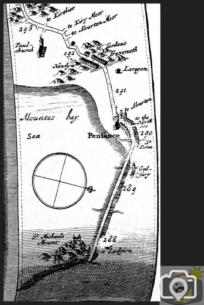
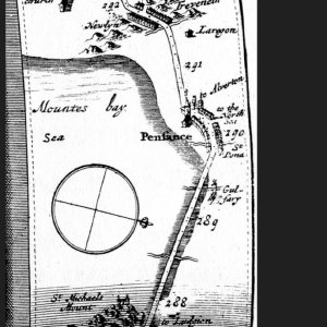
A section of the first Road Maps of Britain, surveyed and prepared by John Ogilby in 1675.These surveys were made with 'Wheel Dimensurator' and an early theodolite. In that way a fairly accurate route could be recorded, with gradients. Streams, bridges and fords were recorded. This was to set out the Post Roads. Having crossed the sands below Gulval with the actual coast to the North side of the 'road', the coaches go through Chyandour and up through Penzance, passing a road which continues North, and then on to the position of the Market House, where the road breaks off through Alverton. Just what is shown around St Mary's Church, I have not yet fathomed. The road continues onwards to Newlyn, past 'Laregon'. There are houses at Treveneth. The numbers on the map are distances from Charing Cross. The whole of this seafront has altered dramatically; This is an exploration of as much written record as I can find.
On the Roman front, in 1819, it is recorded that a Roman Fort was built about a half mile from where Ludgvan Church now stands. It was discovered during the Civil War of c1642, dug up by Parliamentary Forces, when beseiging the Mount.
 
Marazion 1819 : 'the beautiful level green, about three miles in length, over which the public road leading from hence to Penzance is carried on the margin of the tide ..... '
and
'The level green over which the road from Marazion to Penzance passes, is evidently nothing more than the surface of a continued bar of sand, behind which, towards the land, lies a large tract of marshy ground, over which the tide no doubt formerly flowed.'
and
'A vast number of hazel-boughs with perfect nuts adhering to them, have been found between Marazion and Penzance, below the natural bed of soil.'
Which all tells its own story.
 
Some more from Mr Penaluna in 1819 ...
About half way between Marazion and Chyandower, about 300 yards below high water mark, were seen a few years ago, by Mr. Giddy of Penzance, upon an extraordinary recession of the tide, several stumps of trees in their native soil, with the roots shooting out from them, and with their stems apparently cut off. These trees had been felled, in apprehension of the coming encroachment; while the whole trees had been either surprised or neglected.
From Tonkin's MS. The inhabitants of Marketjew Marazion) have a tradition, that the greatest part of their houses (in which there is fine old carved work) were built with oak-trees that grew between the Mount and Newlyn. he also says that off the Long-Rock (between the Mount and Penzance) may be seen in a clear day, about twenty feet under water, a firm wall runnings out directly to the south, and that for a long way. This ( they say) was the wall of a park there.
One day, perhaps there will be a separate publication of Thomas Tonkin's work. Dates from 1715.
 
Of the road through Marazion, Davies Gilbert in 1838 says 'About the middle of the last century [c1750] , which was the great epoch for the establishment of turnpike roads, as the beginning of this century will be considered for their improvement on principles of science and of general accommodation, a turnpike road was laid out from Falmouth, through Penryn and Helston, to the western of Marazion, by which a new entrance was opened from Penzance; and about the year 1775 a large castellated house was built at the western extremity of the town, by Mr. John Blewett, son of Mr. George Blewett, the very considerable merchant, in imitation of the house at Tregenna, near St. Ive's.' That description fits Manor House.
 
The earliest [c 600AD] record of the invasion of the sea in Mount's Bay, is from St Wulvella.
She complained of the encroachments of the sea. The story is that Paul (of Paul village) told her to lay out a row of pebbles at the high tide line, and he prayed as she did so. The pebbles grew into rocks that broke the force of the waves, and from then the tides ceased to eat into the land. Wormonoc says that the way Paul took along the strand was in his day called 'Paul's Walk.' There had, obviously, been encroachments of the sea in Mount's Bay. The buried forest in the marsh states as to to the subsidence of the land. What Paul effected for his sister Wulvella was to bank out the tide, as taught him by St Illtud in Wales. A line of stone wall. The Cressar Reef and the Long Rock were traditionally supposed to have grown out of the line of pebbles laid by Wulvella. A little diversion from the facts of the matter. Gradually the tides invaded, wearing away the earthy seafront, slowed by the revetment pebble walls until the reefs were exposed, thereby preventing further erosion. For comparison see the width of seafront lost near Tolcarne on the 1675 map of Penzance. That is another story.
 
St. Michael’s Mount was a portion of the main land, at some distance from the sea. Tradition, and observation, that this mount once stood in a forest, and was called “The hoar rock in the wood.” In the charter of the Confessor, it is described as 'St. Michael near the sea.' Its exact distance from the coast is not mentioned. Florence of Worcester says, that it was originally enclosed within a very thick wood, distant from the sea six miles, affording the finest shelter for wild beasts. The sea, however, has made great encroachments on this part of the coast. Then there are evidences of fallen trees and recorded inroads, more on that later.
As to the distance of six miles, that would take it to the 'edge' of the Bay, though possibly there was an extended lower shelf around the Bay at that time, over the present reefs.
 
There have been changes in sea level and shore line over the centuries. Something to be remembered in all of this is that Britain is a fortress of land, but in Cornwall rivers cannot re-route and the present cliffs are more resilient than those of other counties. Any coastal areas of less than granite will fast deplete. From Hayle to Padstow, is the most enormous stretch of sand, which, in many places, to the height of sixty feet, and beneath which, human bones and the remains of ancient buildings have been found. From records of the Arundel family, the catastrophe took place about the twelfth century. Radulfus Ymagines Historiarum records another, which was particularly destructive at St.Ives, towards the end of the reign of king John [c1210]. A sudden and unexpected inundation of waters took place in many parts of England, whence many men were drowned, and houses overturned, especially at Exeter and St. Ives. Simeon of Durham writes on the third of the nones of November of sea inroads entombing towns and men in great numbers, and oxen and sheep innumerable. Florence of Worcester in the Saxon Chronicles, writes that a remarkable invasion of the ocean occurred in November 1099. On the third of the nones of November the sea comes out upon the shores, and buried towns and men, very many, oxen and sheep innumerable. On Saint Martin's mass day, sprang up so much the sea flood, and so myckle harm did, as no man minded it ever afore did. To this must be added that Edward the Confessor had granted to the monks of St Michael's Mount the port named Ruminella. Looking at John Leland's Itinerary [c1530] he says There is an old legend of S. Michael that spekethe of a tounelet in this part now defaced and lying under the water. Also, There hath bene much land, building, and wood devourid of the sea betwixt Pensandes and Mousehole.
 
An unavoidable fact is isostasis. The recovery of Britain after the last Ice Age. Penzance sinks into the waves at the present rate of 1.7mm per year. East Coast at 2.1mm per year, whilst Southampton descends at 5.1mm per year. Just what previous rates were can be imagined to have been greater and measurable. To this can be added sea level changes from the melting of land supported ice and the effects of quantities of precipitation on a global scale. Further more dramatic effects may be seen following earthquakes and continental shelf disturbances, which have brought about observed 'purturbations'. At the present rate Mount's Bay has become deeper in sea-water by over 11feet during the last 2000 years, for reasons of isostatic movement alone. Whatever earth banks and grazing were in the bay have been eroded and washed away, from the scene presented to Phœnicians, Celts and Romans. The reefs and rocks in the bay and the coastline of the Penzance area being the bases of the old landscape. Even using the hydrostatic map as a guide, that will not re-build the old layout, for the covering silt, soil, clay and stone has been washed away. What does last longer are tree trunks and seeds. An indicator that this has been a repeating process in the Bay are remains of trees that have been seen at low tides following storms on the beach at Perranuthnoe, radiocarbon gave that the submergence of the hazel wood was c1700 BC. Next I will 'look at' trees and Gwavas Lake.
 
Friday 15th July 1757, a violent earthquake shock at 6.30pm. Felt throughout West Cornwall, recorded by J Harris at Keneggy. It appears that it was strongest on the line from Marazion to St Ives, reported by one gentleman as being stronger than the one 1st November 1755, which he had witnessed. Another eathquake tremor weaker, happened on the 13th January 1860. Just how much an
earthquake would add to the collapsing shore can be guessed upon the descriptions of the effects on houses shaking so violently that those inside ran out fearing their collapse. At Bude are to be found a submarine forest twenty feet below the level of the sea surface. At Maenporth another submarine forest. It is tempting when looking at the forest remains seen in the Bay to imagine that they for a apart of recent invasion of the sea. But, they being fossilised, William Colenso of the Cornwall Geological Society states that the exposed trees are from the Neolithic Period, dating 1100BC. He that says Christopher Hawkins was draining a marsh at Hayle in 1740 and found oak four feet under clay; John Roberts in 1750 was digging at Sennen and found a large deer and an oak tree at 30 feet depth. Dr. Borlase states that 'on the strand of Mount’s Bay, midway between the piers of St. Michael’s Mount and Penzance, in the 19th of January, 1757, the remains of a wood, which, according to tradition, covered a large tract of ground in Mount’s Bay, appeared.' These remains consisted of hazel and alder, with some forest trees, including the elm and the oak. The hazel-nuts were abundant; and even fragments of insects, particularly the elytra and mandibles of the beetle tribe, still displaying the most beautiful, shining colours, but crumbling into dust on exposure to the air, were found amid the vegetable mass. With the advent of the 1881 storm and the very low tide in 1883, the forest was exposed again. There have been massive changes in the area, and the raised beaches prove this (one in Morrab Road, in line with the Art School, exposed when cutting foundations). A raised beach shows the sea level was at one time at that height. It was considered a possibility that Cornwall had a chalk barrier off the southern coast of Penwith. Bromton writes of the sea burst its boundaries; and did not return within its customary limits, till after a lapse of about two days. This occurred in the reign of Henry II, 1176AD. There are lands recorded at below Chyandour that were subject to rents. There were land below Newlyn in the area named Gwavas Lake that were subject to tithe. Chyandour until 1840 was a fishing village inlet, a cove. Cottages stood on the cliff along the road edge which was lower than at present. It is said that the lands that lay between 'The Green' and the sea at Newlyn was surrounded by a wooded bank and held a freshwater lake. In around 1810, the tide was at an extreme low. Traces of unfossilised trees and marshy ground could be seen, a dugout freshwater canoe was found. I cannot believe that any better explanation exists as to just why this area of Mount's Bay could be known as Gwavas Lake, given the gradual erosion of the bank, that would have eventually happened in a moment with a rush of sea water. One of the reasons for this lake's memory is that it had a hermitage on its bank. There was a saintly man with the power of healing and part of the building was an oratory.
 
So, here is a picture. The sea has been at the top of Morrab Road, at below the present level of Lariggan Beach, and rising again. In the meantime the normal detritis of plants and animals, river and ground transmitted solids accumulate as earth, clay or sand over 3,000 years only to be once again eroded and carried off into the sea over the last few hundred years. What the total 'sea rise' (or rather land sinking) has been since 54BC is probably measurable from other sources, but suffice to say that the level rose by 500 feet when the ice sheets began to shrink back in 7000 BC. Land had tilted upwards with ice bearing down on the Scottish Highlands. Cornwall is now going down again. Taking into account violent winds, tidal pressure, high waves, purturbations [ violent surges 10 feet observed c1750], agitation of the sea [5feet observed in 1843] and the tsunami of 1607, the coast of Cornwall has to have changed dramatically. William Camden said The inhabitants are of opinion that this promontory did once reach further to he west; which the seamen positively conclude from the rubbish they draw up. Nets drawn off the area often contained parts of buildings, such as doors or windows. The difficulty comes when relying on myth that the source of the myth in folklore arrives from unsophisticated thought. They had no knowledge of isostatic rebound. There are few thoughts to be considered. The writings of Diodorus by an intelligent Greek state the Cornish took their tin to an island to sell it to merchants. The island was off Belerion. It was called Ictis [the otter]. The tin was carried in drawn carts, the length of Cornwall. The Phoenicians came to Scilly (Cassiterides) and Cornwall, and were protective of their sources. At the time, there was no port in Mount's Bay, although there must have been others further up the south coast. Whatever Ictis was is no longer to be seen, why? As a 'tin port' of the time the area now called St Ives would not have made sense. Looking at road maps, with the exception of modern construction, they grow out of development from footpath and bridle path. Lines grow to churches or townships, or mineworkings...A long standing legend is of The Lost land of Lyonesse. Just how much lies in truth or fiction is not known. From calculations of isostatic rebound a minimum of 11feet of drowning must be made. From observations made in the rest of Cornwall, it would appear that many feet of immersion has taken place over 2000 years. By lowering the surface of the sea in the region between Land's End and The Isles of Scilly, reefs would be exposed, and bearing in mind that would have been surfaced with soil, they would certainly appear to the observer as a series of islands, as Diodorus writes; bear in mind that he was well aware of the Cassiterides and wote separately of them. Take the rocks known as Seven Stones Reef, they are called Lethas in Cornish, it is there that windows have been raised by fishing line. Now, with these thoughts in mind, look at the rocks now called The longships, raise the masses out of the sea and add soil and substance, look at the cliffs of Land's End, and ask if the road from the tin mines led out to Land's End and to an island off the coast of Belerion. I do not know of when the group received the name of Longships, or why. For me it is Ictis.
 

Media information

Album
Time past
Added by
treeve
Date added
View count
7,600
Comment count
38
Rating
0.00 star(s) 0 ratings

Share this media

Top Bottom