The Lidden, Newlyn
trepolpen

The Lidden, Newlyn

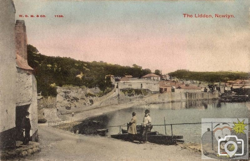
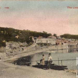
Thinking of Lidden Road off New Road near Wherrytown, I was confused by this 'Lidden' depicted here though the word has a connection with the sea area off Newlyn called Gwavas Lake. I can't find the name in modern Newlyn and think we are looking at the section of road outside the Red Lion across the water in view of the Chapel visible there. I look to Treeve for clarification (or others).
I am about to post up the map of original Newlyn, with a photo of the fish market on the land by the river. This is a really good picture of our history; shows just how our present day landscape depends very much on what went before.
 
In view of the fact that the information I was given was wrong, I am erasing the suggestion made years ago to me.
 
With all due respect, I think you ll find authoritative Cornish place-name experts like Padel, Holmes, Hodge, Gendall and Weatherhill take Lidden to be derived from lyn / lynn (with preocclusion hence the d s) meaning pond , pool , lake .
 
So, this derives from the days when Gwavas Lake was just that, before the inundations?
 
Seemingly though I can t say definitively; it s echoed by the name Newlyn which is believed to be derived from Lu Lynn (Fleet Lake)
 
Lach-Szyrma suggests New Lake, Price suggests Noath Lyn = open lake, either way it does fit with the fact of the inundations, which makes the naming very old.
 
Recorded as Nulyn (1279) and Lulyn (1289), Padel (foremost Cornish place names expert) says, Apart from the earliest form, Lulyn is the standard spelling until the mid-14th Century . The problem is that lu is recorded mainly with the meaning army and only once with fleet as its translation. I don t think Cornish can be said to have existed at a time when there was a pool or lake but it may be a folk memory, of course, that gave rise to the name but perhaps an inlet for boats to safely moor up may explain the pool or lake better.
 
With geological and climatic records, as well as diary records it has been confirmed that there were two inundations in the early 11th century, and this took place over the whole of the South Coast, other increases in water levels occurred elsewhere but not so dramatic. It all changed our coastline, and is considered to be a tsunami or similar; it was around this time that the forest was drowned and our Bay changed shape; this would have altered any port arrangements preceding quite dramatically.
 
If the inundaton was at that time does this not mean that the old stories about Phonecians sailing in and trading for Tin at Marazion and the Mount could not have happened as they were inland?
 
There is a considerable amount of speculation as to just where these visits actually took place, because the place names cannot be identified specifically. I am looking for any type of survey of Mount s Bay to show the areas of sunken forest; I have seen two photographs at extremely low tide, showing the stumps. The Marazion Marsh area is a submerged forest area, as well.
 

Media information

Album
PENZANCE - MISCELLANY OF POSTCARDS & PICTURES
Added by
trepolpen
Date added
View count
3,349
Comment count
20
Rating
0.00 star(s) 0 ratings

Share this media

Top Bottom