Alverton Bridge Aerial
treeve

Alverton Bridge Aerial

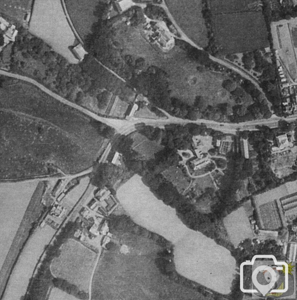
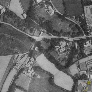
Taken on 12th July 1946.
Incendiary craters can be seen on the grounds of Tredarvah House.
The wooded area to the lower edge of the grounds is home to a number of fox families; the ground is well drained.
The lane between 'Tredarvah Farm' and Tredarvah House was left with no owners. When Tredarvah Estate was under way, it was considered to upgrade the lane, but with no owners, it was left as it is now. Considerable research was made by Grove Hill Estates and solicitors AWH Harvey, with complete Silence as to the owner, as she had died without making transfer to anyone - it is therefore ownerless.

In 1946 it can be seen that there is no vestige of a building in the corner site to the upper side of the brook. To the lower side is the old tannery works, trees, then the farm, cottage and a smaller cottage, which is now an open space, at the head of Love Lane.
Just got back from England! Meyrick quoted what Q said and qualified it with his own observations, saying that there was nothing of the fabric of the well left when he visited.
 
Well, the 1936 may show it. Sorry to be obtuse. but how did J Meyrick identify the spot with a Grid Ref, when the well was not there?
Ancient and Holy Wells of Cornwall by L and M Quiller-Couch, was written in 1894. Whatever was there was described fully enough to indicate it was not original, either in position or in fabrication. It must surely have been removed from another position and I will still check over my 1839 Tithe map, when I get a chance.
 
PS there is a well in the woods near Castle Horneck, which appears very old, I will post up pictures when I get a chance.
 
No, Treeve, you re a cutie (blows kiss - emoticon missing), not obtuse. One day, I shall scan in the page and you can judge for yourself whether Meyrick had any grounds for his placing of the well.
 
I had a copy of the L and M Quiller-Couch (1895), but it was sequestered by an unmentionable, so I have recently ordered a replacement.
It is Mr Meyrick s assertion as to specific location in the face of a void of no apparent fixed abode. read#
Again, I have to ask whether it has been mentioned by any other persons who were in the immediate vicinity, know what I mean?
 
Thanks for the scan, I can see now what is happening - M Quiller Couch mentions no mention of the stream, I feel it was further up the lane.
Maybe next week things will be easier to take a careful look at the old maps.
I will take a look through Borlase book as well.
 
Without getting into the family tree of Quiller Couch; the original book was compiled by Thomas Quiller Couch (father of Q ) who died in 1893, and written by Lilian and Mabel (sisters of Q) Quiller Couch, printed in 1894 by Charles Clark.
Quoting from from the original book by M and L Quiller-Couch of 1894. Headed Well at Castle Horneck ; First off, Tredarvah Farm, under whatever name it was rejoicing in 1894, cannot be imagined under any circumstances to be at Castle Horneck . Then, the well is described as being at the side of the road . No mention of buildings or river. On the 1875 map of the region, the route of the river and the access lane to Castle Horneck is very clear, passing Alverton Lodge and Polgoon, springs and watercourses shown, together with pools and gardens. The description does not state Lesingey, Rosehill, Polgoon or Alverton Lodge, just Castle Horneck .Despite archaic wells being marked on these OS maps in other locations, this one is not. Then, the top of the well is described as being level with the road with two granite steps to get down to the entrance from that road, and the fact that the well faces the hedge . All of that would occupy some considerable space and would be a recogniseable feature on any map of the time, particularly since it is not described as being recessed into the hedge, or through the hedge. There is, however, such a feature marked on the OS opposite the stables/farm buildings of Castle Horneck, on the lower side of the slope, at the head of a stretch of water that existed at that time.
 
I have spent some time perusing your full comments, Treeve, and at the same time referred to my OS Explorer 7 map. I think perhaps your last sentence holds the answer if you mean an old OS map. On my modern one, I can only find a spring adjacent to the river and roughly north of Castle Horneck and west of Polgoon, and, further on, a well is marked just beyond the farm buildings at Rosehill. Thanks for doing all that interesting research.
 

Media information

Album
Dave Clarke
Added by
treeve
Date added
View count
4,851
Comment count
29
Rating
0.00 star(s) 0 ratings

Share this media

Top Bottom