You are using an out of date browser. It may not display this or other websites correctly.
You should upgrade or use an alternative browser.
You should upgrade or use an alternative browser.
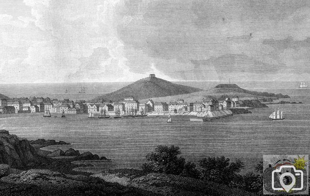
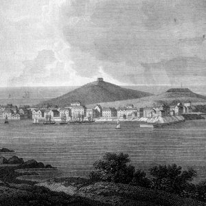
St Ives 1765
St Ives 1765, with the old pier; drawn by J Farington, engraved by S Middiman, published T Cadell
and W Davies in 1813. Scanned from my original. At that time, the sea front of St Ives stretched as
a sand bank from the west, to a rocky shallow cliff on the east; the sudden break appears to verify
the idea that The Island was indeed an island. Landing would have been over the sand shore, or up
steps off the inner end of the small pier.
St Ives
Despite the prominence of Cornwall standing as bastion to the far west,
first visual contact to all arriving from the western approaches,
we do not offer any safe
haven for invading fleets, nor landing for incursion to the rest of the country.
To the north 80 odd miles of reef, sands and cliffs.
Currents and winds that challenge and wreck, and that included ships of the King.
These waters were the hunting grounds for pirates, privateers, smuggling;
and on rocks and cliffs the taking of plunder from wrecks, much from under other flags, but much
from Cornish harbours,
and much of that backed or originating from powerful families of the area.
Between Land's End and Hartland Point there are but two ports that can offer
any safe haven for passing and berthing merchant ships. Padstow and St Ives.
Padstow has her rocks, cliffs and Doom Bar,
St Ives has the pervading winds and the wide bay that draws unwary ships into her lair.
St Ives (in ancient records Porth Ia) takes its name from St Ia, who came from Ireland with St
Breaca and others.
The market of S Ives was granted in 1295 by King Edward I, within his manor of La Nant.
Further markets and fairs were granted by Charles I.
In 1300 St Ives was merely a collection of fishermen's huts on the shore.
By the time of Henry IV there is first mention of St Ives by name,
in that the first chapel was resolved to be built by the grateful inhabitants.
In 1408, it being considered a long way to the mother church at Lelant, a petition resulted in the
new church
at St Ives being consecrated 3rd February 1434.
Around that time The Island was fortified with a surrounding wall.
Later came the four mediaeval chapels -
St Leonard's by the old quay (built 1494, which became a smith's shop in 1770);
St Nicholas on Pendinas point [The Island];
Higher Tregenna chapel and Brunian chapel.
It has been said that Pen Dinas was indeed a tidal island (as the Mount is today)
and the rocky causeway has since been covered by sands and soil.
These accounts of raging seas and choking sands may be describing that invasion of land.
Since the time of Henry VIII it appears that St Ives began being pressed by sands.
1540 Leland - most part of the houses in the peninsula [of St Ives]
be sore oppressed or over-covered with sandes that the stormy windes and rages castith up there.
This calamite hath continued there little above 20 years
1577 Holinshed - On The Island (Pendinas) stood a pharos or light for ships that sail by these
coasts by night.
there is also a blockhouse and a peer on the east side thereof, but the peer is sore choked with
sand ;
in 1812 the pharos and blockhouse remained and was in use as a government store.
1590 Norden - St Ives, a poore haven towne, and a market,
there is a bay but the sande hathe bene verie prejudiciall unto it,
and made it insufficient to receive ships of any burden, but fisher boats,
who being well exercised bring profit to the inhabitants, being great store of fish upon that north
coast
1602 Carew - The town and port of St Ives are both of mean plight, yet with their best means and
often to good
and necessarie purpose succouring distressed shipping.
Order hath been taken and attempts made for bettering the roade with a pier.
This mean plight and desperation must have had its effects upon the townspeople,
for in 1564 events showed St Ives to be very much in the market for stolen goods.
The townspeople, headed by the town constables, plundered a Dutch ship in the harbour.
In that same year,
Martin Frobisher had with his crew captured a French ship intended to take tapestries to Philip II.
They took the ship to Ireland and wrecked it deliberately, bringing the tapestries to St Ives.
It resulted in his imprisonment at Launceston jail.
In 1705 there were 240 houses; in 1812 there were 712 houses with 3,281 inhabitants.
During the wars of 1739-63 St Ives was issued with 16 guns,
but the towns had to build the batteries themselves and provide ammunition.
In 1804 another 12 guns were presented and new battery erected, again by the townspeople.
Before 1766, there was a pier which ran from Carn Glaze, which appears to have been built before
1577; this may well have been altered or re-built during that time.
John Smeaton, celebrated engineer of Leeds (designer of Eddystone lighthouse and Hexham Bridge,
etc.,.)
designed and directed construction of nine harbours the only one that commemorates his name is that
pier at St Ives.
He compiled his report in 1766, the pier was to be 360 feet, of 35,000 tons of stone. It was built
out from Castle rock and completed in 1770. The octagonal lookout is part of Smeaton's design.
However, the first light from this was seen in 1777.
A wharf was constructed in 1770.
In 1864, a timber outer pier was built but began to collapsed very shortly after.
In 1811-1817 a stone breakwater was constructed to the designs of Richard Trevithick.
There were plans to construct a lighthouse of timber in 1830; the great shipbuilder Samuel Warren
came down from Bristol to work on this, it appears it was built in 1832. Samuel Warren was
encouraged to stay on and work for John Harvey of Hayle to build the specialised ships to carry
machinery and boilers to far off shores.
1888-1890 A stone extension to the pier was built, with a new 32 foot lighthouse.
Its light was first seen in 1894 when the work was finally completed.
In 1894 the West Pier was built.
Wharf Road was built in 1922.
Raymond Forward
